 |
| Field Trip! |
I am now officially able to say that we lived through Field
Trip February. Some of you may
have noticed field trips mentioned a few times on my FaceBook page, or on the
museum’s page if you follow the Museum.
Now that the chaos is over I can take a minute and reflect on an
interesting program.
One of the problems with Imperial County is that there
aren’t many places for schools to take kids on field trips. In January, a teacher from McCabe
Elementary in El Centro talked to Jessica about bringing all of McCabe’s 4th
graders out to the museum for a field trip. There was no way we were going to be able to handle all the
kids at once so we worked out a plan where each class of 30 kids would come out
to the museum on a different Wednesday in February instead. Then of course, we had
to figure out what we were going to do with the kids. None of us are education experts, especially when it comes
to younger kids. We don’t know
what they are learning in school, what is ‘age-appropriate’, etc. So we were going with what we thought
the kids would be interested in seeing and doing while at the same time hoping
they might learn something from us, even if it was just that the museum was
cool and they should make their parents bring them back on a Saturday. I think the end result has been better
than any of us were expecting. I've had three kids so far tell me they want to work here when they grow up.
We start the kids off with a short talk about Imperial
Valley and its’ history. How there
used to be an ocean here, then there was Lake Cahuilla, then climate change
dried up Lake Cahuilla and left us with the Salton Sea instead. How climate change effected the people
who lived here, and how you knew the kinds of animals that were hunted here
because of the change in the tools and projectile points we find in our
collections here. They lose
interest in this before we do, but then they perk up when we bring out the
toolbox. First they get to see
shell fossils and pass those around, as proof that there really was an ocean
here. Then Neal opens one drawer
of the tool box and pulls out a hammer, asks the kids what it is (they all get
that one) and where they think it is from.
The answer is Home Depot because Neal loves Home Depot, and the next
question of course is, where did people get hammers thousands of years ago when
there was no Home Depot? The
answer is: the land all around them was the original Home
Depot. Neal pulls out of the
second drawer a hammerstone and asks the kids what it is. The answer, inevitabley,
is: “a rock”. True, but it’s also a 6,000 year old hammer. They get to pass
that around and get a feel for how it fits into their hands. This process is repeated with a knife. Our cool obsidian knife acts as the
original knife and the kids are always ssuitabley impressed with it. Neal shows them a giant chunk of
obsidian we have and gives them a rundown on how the Native Americans might
have made the chunk of obsidian into the knife they see, courtesy of a hammer
and antler to help chip the point to its’ desired shape and point. Then the same thing with a
screwdriver.


We give them a brief tour of the museum and divide them into
3 groups. We debated a lot about
what to do with them and finally settled on three activities. The first one, for us, is a
no-brainer. Coiled clay. It’s something we’re really good at, becoming known for, and kids love clay. The second activity we decided on is to have some boxes of
rocks, both polished and not, for them to look at, try to match the rock to pictures
in books, look at sand and rocks under a microscope, etc. They also get to see some of our
collection of projectile points (arrowheads to the lay person). Jessica always jokes that this is the
filler station between the two cool activities, although kids love rocks so I
don’t know about that.
 |
| Projectile points, newly discovered |
The third station is my station: hiking in the desert. We usually walk up to the ridge behind
the museum and go to the geoglyph on our land, although if the wind’s too high
or we get short on time I just walk them around in the wash. I show them Ocotillo cactus, brittle
bush, and creosote, and talk a little about what it is and what it does. The creosote is always a big hit
because I pour a little water from my water bottle on it and let the kids smell
it. Creosote smells great after
the rain and they think it is cool to be able to water the creosote and get the
same effect. At least one kid
always asks if they can pour water on the creosote and try it themselves, like
I’ve got a trick water bottle and they need to double check me. I have them look for quartz, hold it up
to the sun and explain how quartz is the only rock that sunlight can shine
through and moss will grow underneath it.
Usually at least one of the kids can find a piece with moss on the other
side so they know I’m not making it up.
I have them pick up rocks and look for ones tham would make good tools,
and they get into it. Usually the
geoglyph itself is kind of anticlimactic when they’ve been playing with rocks
the whole way. I think it’s kind
of funny how they always feel they have to show me every rock they find, and I
have to approve of the rocks.
Sometimes just because it’s pretty, but sometimes they do ask if it
would make a good tool and what it would do. I think it’s kind of cool how much they enjoy it, and the
hike makes them want to get outside more and explore their area, hike more, or
learn more about rocks and plants.
It always blows their minds when I tell them that I’m from New Orleans,
a place where there are no rocks!
Hard to imagine when they’re surrounded by them!
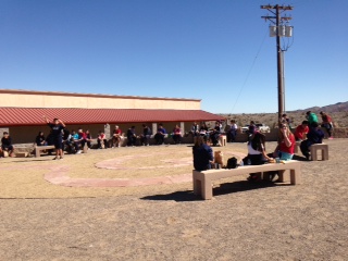 |
| Outside picnic |
The field trips have been pilot programs and we’re trying to
hire someone with an education background who actually knows school curriculum
and can adjust the programs to fit different grades. But I think we’ve done pretty well on our own to start. It’s made me remember when I was doing
Care Cadets at the LA/SPCA every summer, teaching kids only a little older than
these about volunteering at the shelter, working with animals, training
dogs. I always loved that and
thought that was the kind of thing I would want to do as a career. I could totally seen myself as the
education co-ordinator for the LA/SPCA when I went off to school. I loved working with the kids, even
when they were being exasperating. I loved talking to people of all ages about
how to take care of animals, spaying and neutering their pets, and all sorts of
things. It’s funny, because I
always think of myself as not being very good with people and not liking
kids. But then I get in these
situations and it’s great. Maybe I
don’t know myself as well as I think, or I’m now remembering parts of myself
and what I used to enjoy. Either
way, as crazy as the field trips have made February, I’m really glad to
have been a part of it.


